Saturday, August 4, 2018

2018 Orcas Island Fly-in


The first weekend in August, the Eastsound EAA chapter sponsors a fly-in and campout at KORS. KORS is located on Eastsound in the San Juan Islands, WA.  I have attended several times over the last decade and this year, I invited a couple of passengers to fly up and camp out with us. The 182 was our aircraft of choice as it can typically handle four passengers and camping gear. When we fly as a family with full fuel and cargo, the 182 is well within loading limits. But this year we had two non-family members who had their own camping gear and along with their combined passenger weight required some scrutiny in aircraft loading. After punching in the numbers in the Garmin Pilot weight and balance feature and using the ‘Quick Set Fuel’ option, we we’re good to go with 56 gallons of fuel and all of our stuff, while remaining just under max weight and within the flight envelope.

We loaded the airplane with two tents, four sleeping bags, camp chairs and miscellaneous items, and departed KSLE late Saturday morning for the planned two-hour flight. The flight north bound took us over Olympia, Bremerton, Port Townsend and then after getting a clearance with Whidbey NAS, we transitioned the class C airspace into the San Juan’s. You can navigate into the San Juan’s around the class C airspace, but on a weekend, traffic in that area can be pretty crazy so getting radar services is a good idea. We probably had half a dozen traffic advisories from the controller while crossing the Strait of Juan De Fuca into Eastsound. After getting dropped by Whidbey we setup for a right pattern for runway 34 at KORS.

When we landed, there were a lot of airplanes and tents lining the taxiway and we were marshaled into a spot on the grass where we pushed the airplane in and setup camp.


After getting the campsite situated, we made the short walk into town for a late lunch and a trip to the grocery store to pick up snacks. One of the things I like best about this fly-in is that EAA hosts a pot-luck dinner on Friday and Saturday night and the Orcas fire department hosts a pancake breakfast at the fire station across the street from the airport on Saturday and Sunday morning so you don’t have to pack a lot of food for the trip. 
After a nice lunch at a local cantina in town called Mijitas, we walked back to the airport for some relaxing time at the campsite and to enjoy looking at all the different airplanes including some vintage models. 

The next morning, we grabbed breakfast at the fire station and packed up the airplane for our next stop on the San Juan adventure. The plan was to do some kayaking and we had planned to fly to Friday Harbor and rent some kayaks for a few hours to tool around the harbor. But after checking the weather, KFHR was fogged in with a 100’ overcast. Fortunately, the marine layer in the San Juan’s doesn’t affect all of the islands all the time as KORS was clear and so was Roche Harbor (WA09). With that info we departed Orcas and made the 10-minute flight to Roche where we rented some kayaks and paddled around the marina and adjacent waters. Post kayaking, we grabbed some lunch at the Marina and headed home.
Marine Layer

Approach Into Roche Harbor

Thursday, May 10, 2018

Rapid Decompression


Hypoxia Training
Early in May, a colleague and I flew to Renton (KRNT) in order to experience the FAA’s portable reduced oxygen training enclosure (PROTE). This chamber is capable of producing hypoxic environments at ground level by altering the fraction of ambient oxygen. This avoids some of the risks associated with pressurized altitude chamber training. The purpose of the chamber is to learn how you will react when experiencing hypoxia and to learn some of the signs associated with hypoxia. The chamber let us experience what it would be like at 27,000’ without supplemental oxygen for five minutes. 

The Flight
We had been watching the weather for a week leading up to the flight and the extended forecasts would alternate back and forth between VFR, MVFR, IFR. Making the flight under IFR conditions wasn’t the issue, but there was a cold air system coming and the freezing levels were forecast to be at 6000’ which is the typical north bound altitude assigned between Portland and Olympia.

On the day of the flight the conditions enroute were reported as VFR with rain showers along the route, so we expected we’d have to deviate around and under areas of lower clouds and rain. We departed KSLE VFR and encountered our first area of rain and low visibility near KHIO, but we were easily able to deviate around the spots of weather and as we approached KSPB there was some precipitation and spotty MVFR conditions ahead. As we neared Kelso (KKLS) the ceilings started to drop and the visibility was decreasing from VFR to MVFR. After a short time of being in low visibility we decided that we needed an IFR clearance in order continue the flight.

While I looked up the ATC frequency for getting a clearance, the pilot flying made a 180 degree turn back to the VFR conditions that we had previously come from while I negotiated an IFR clearance to KRNT with ATC. Since we didn’t have an IFR flight plan filed in the ATC system it some back and forth between the controller to get all the relevant details of the requested clearance, like aircraft type, equipment (/G, /A, etc.), desired route (in our case direct OLM and then KRNT. But once the controller established radar contact with our aircraft he asked us to assume our own terrain clearance until reaching 4000’ before proceeding on course to OLM. For the remainder of the flight he flew the airplane while I handled communication duties with ATC.

Our assigned altitude was 6000’ (remember earlier I mentioned the freezing levels were 6000’)? As we settled in at altitude we were closely monitoring the outside air temperature and watching to make sure that any visible water droplets were moving across the airplane structure and not becoming stationary (freezing). Sure enough, after a short time at 6000’ ice started to form on the wing strut and the leading edge of the wing. Though it was very light ice accumulation, we immediately reported the ice to ATC and requested a lower altitude. We were assigned a new altitude of 5000’ and after descending, the OAT increased to +2 degrees C and the water on the airplane surfaces was moving again.

Once reaching OLM we were switched to Seattle approach and began receiving vectors to the north west of Seattle in preparation for the GPS 16Z approach at KRNT. Overall the flight from KSLE to KRNT took about an hour and a half and about one hour of that was in instrument meteorological conditions (IMC).
GPS 16Z

Landing 16


Hypoxia Training
The chamber holds six people and before each group went in, we were briefed as to what to expect and how to operate our pulse oximeter and demand flow oxygen mask. We were given a clip board with some check boxes that we were supposed mark when we experienced symptoms of hypoxia and some sample math problems to work while in the chamber.  Once in the chamber, the instructor would ask random questions, like “if you burned 10 gallons an hour how many gallons you would use…”. He would pick on individuals that appeared to be out of it do to hypoxia. In fact, a few participants’ heads went limp and the instructor had to put their mask on them. The point of the training wasn’t to see how long you could go without oxygen, but to demonstrate to yourself what your hypoxic limits were and the symptoms that you experience when at high altitudes. As for me, I made it about 2 ½ minutes before feeling too dizzy and nauseous to continue, so I donned the oxygen mask and recovered.  my colleague went the full five minutes without putting on the oxygen mask.
  
The Return Flight
After the training, it was time for lunch before flying back to KSLE so we took the opportunity to fly to one of my favorite dining spots, Mukilteo Coffee Roasters on Whidbey Island, which is adjacent to W10. W10 is located on the southern end of Whidbey Island and is a 20-minute flight from KRNT. The airport is surrounded by trees and has a 2500’ runway, and the café is a short walk up a path from the runway. After lunch we headed for home and were able to make the entire return flight in VFR conditions.

Sunday, October 8, 2017

Nehalem Bay State Park

I have been to this state park a handful of times by car and every time have said to myself "I need to fly into here sometime". As it turns out, we were looking for a family destination to fly to on a Sunday afternoon and we wanted to visit the beach so Nehalem fit the bill perfectly. Nehalem Bay (3S7) is located between Tillamook and Manzanita adjacent to the beach but sheltered by woods. The airport can be challenging as the typical coastal winds create turbulent conditions on approach to runway 33
but as you cross the bay and enter the opening in the trees at the runway threshold, a shear is created making for a challenging landing. Also, the woods around the airport are home to deer and elk, so you have to be prepared to go around if these critters are lingering on the runway. In fact when we departed in the early evening there was a family of deer wandering around the airplane.

The beach is a 15-minute walk from the airport and the Nehalem Bay inlet is accessible by walking down to the end of runway 33. The airport has campsites on the field for fly-in campers, but there are numerous reservable campsites across the street in the state park. If you are visiting for the day, the town of Manzanita is about a two mile walk from the airport.


Deer Crossing


Friday, June 30, 2017

Scenic Flight Around Mount St. Helens

I had a client who wanted to fly a relative around Mount St. Helens so we decided to turn it into a dual cross country by landing at an airport greater than 50 miles from our point of departure along the way. It was beautiful June day with light winds so we were able to fly around the mountain without getting bounced around as one typically would on a warm summer day.

Circling
Mount St. Helens

Saturday, April 15, 2017

Short Hop Across the Oregon Cascades

I have been trying to fly over to Bend this winter, but the weather hasn't cooperated on the days that I'm free to fly. A clear day finally arrived and  we loaded up the club's 182 and departed for KBDN. As we climbed to 7,500, we pointed the airplane between Mt. Washington and Three-Fingered Jack, which kept us clear of two wilderness areas and offered one of the lower eastbound mountain crossing altitudes. As we got closer to the pass, we climbed briefly to 8,500 to increase our margin for terrain clearance and looked for our crossing point, which was the junction of highway 22 and highway 20. There is also a state airport (8S3) at that junction that makes for an ideal landmark.
Over Santiam Junction (8S3)
After crossing the pass, we started our descent into Bend and dialed up the AWOS and started monitoring the KBDN CTAF frequency. At about 15 miles, the airport was visible and we setup for a right pattern entry to runway 16. Though the sectional and third party airport information websites sites list the pattern flow as left traffic, there is a permanent NOTAM in place that calls for right traffic to runway 16 for fixed wing aircraft as there is a high volume of helicopter training at the airport and rotorcraft fly left traffic for the same runway.
After landing, we fueled the plane and walked across the tarmac to the Pickled Pig Restaurant. The restaurant is located on the second floor of one of the FBO’s and has nice views of the airport both inside and from the outside deck. They serve breakfast all day and tout their award winning barbecue on the menu.

The flight back was slightly bumpy as the winds had picked up and the temperature had warmed since our arrival. The forecast called for a broken layer forming at 5:00 pm, but was starting to form a little earlier than expected, so we had to pick our way in between and sometimes over the cloud layer. We opted in most cases to climb above the deck instead of going under in order to keep a safer altitude above terrain to avoid turbulence and other mountain phenomena that occur when wind blows across a ridge. 
Mt. Jefferson and Three-Fingered Jack

Overall, I’d recommend the Pickled Pig as a breakfast or lunch destination if looking for a fun flying outing and mountain crossing. Though, I’d recommend going early in the morning and returning before the afternoon winds and temperatures rise as the ride could be quite bumpy (especially in the Summer).

Saturday, January 14, 2017

Dinner in Chehalis

Willamette River at Sunset
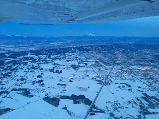
One of our recent club fly-outs was to Chehalis, WA. (KCLS), to grab some dinner and get the opportunity to log some night cross country time. We departed before sunset and enroute watched the sun set and eventually see the skies darken as we crossed into Washington. The Willamette Valley had experienced some snow a day or two prior to the flight, so there were some photo opportunities for snow covered arial shots.


We arrived at KCLS in the dark and after parking, made the short walk to the Riverside Golf Club adjacent to the airport. After a nice meal, we loaded up and flew home on a cold clear night which seemed to offer unusually exceptional visibility as we were able to see the lights of Salem from what seemed like 75 miles away.